
Newport (R.I.)
Found in 110 Collections and/or Records:
Mary A Smith: History of the Navy in Narragansset Bay oral history transcription
Narragansett Bay military installation maps
Maps of installations around Narragansett Bay.
- I-49 Goat Island, U.S. Naval Torpedo Station
- I-50 Gould Island U.S. Naval Torpedo Station U.S. Naval Air Facility
- I-51 Rose Island U. S. Naval Torpedo Station
- I-52 U.S. Naval Training Station
- I-54 U.S. Naval Training Station Rifle Range Sachuest
- I-68 U.S. Naval Magazine Prudence Island
- I-47 Fleet Wharf Area including Small Craft Maintenance Facilities [etc.]
- I-42 U.S. Naval Hospital
- I-41 Anti-Aircraft Training Center Price’s Neck
- I-39 Motor Torpedo Boat Squadron Training Center Including Motor Torpedo Boat Repair Training Unit Melville R. I.
- I-36 U.S. Naval Fuel Annex [Naval Supply Depot] Areas Nos. 2-3-4, 5
- I-35 U.S. Naval Fuel Annex [Naval Supply Depot] U.S. Naval Net Depot Melville R.I.
- I-28 U.S. Naval Torpedo Station Annex No. 3 Fall River, Mass.
- I-5 Signal Station Block Island, R.I.
- I-48 U.S. Naval Supply Depot Public Works Department Marine Barracks U. S. Naval Torpedo Station Annex, Coddington Cove Area Middletown R. I.
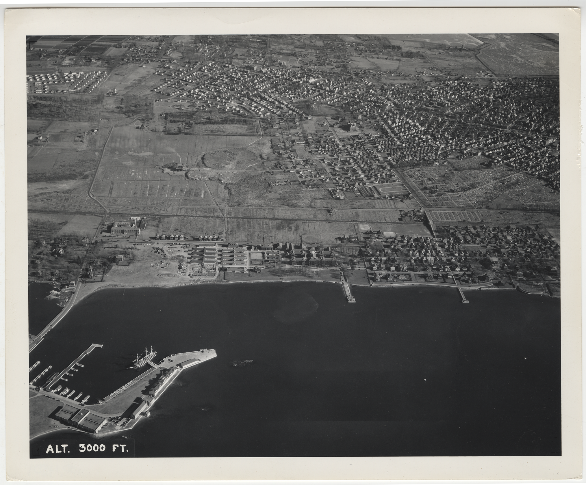
Naval Hospital and Newport aerial photograph
Naval Hospital and Newport aerial view, 1941 Dec 22
Black and white 8x10 photograph of an aerial view of the Naval Hospital Newport and the surrounding area at an altitude of 3000 ft. Newport neighborhoods are visible as well including the Point and the Broadway area. Third Street and Farewell Street are clearly visible and the farmland separating the Naval Station from the City.
The reverse of photo identifies it as an official photo by the order of the Buureau of Aeronautics, and stamped by the U.S. Naval Air Station, Quonset Point, R.I. It also identifies the Local Neg, No. Quon X-194; Date 12-22-41; Subject: U.S. Naval Hospital, Newport RI.; Altitude - 3000 ft; View from West, Horiz. Dist. - 10,000 FT.; Lens - 12 inch; Time - 1203.
Naval Training Station map, circa 1942-1946
This map was annotated by Marple labeling the buildings where he ate and worked while at Naval Station Newport.
Navy Housing and Naval Supply Station, circa 1942
8x10 black and white aerial view of Navy Housing and Naval Supply Station, from 5000 ft.
Newport Bridge, circa 1975
4x5 color photo showing the newly built Newport Bridge
Newport Harbor, circa 1940-1941
8x10 black and white aerial photo of Newport's Inner Harbor
Newport Harbor, circa 1940-1941
8x10 black and white aerial photo of Newport's waterfront (wharfs)